UPDATED: Architecture Month Webinar: Flood Resiliency for the National Mall

Please join us on June 3rd to learn about the existential threat of flooding on the National Mall, view designs for a comprehensive solution, and contribute your ideas.

In this hour-long webinar, the National Mall Coalition will present a unique approach to resiliency on the National Mall, one of the country’s most important public spaces affected by flooding. This event is part of Architecture Month 2020: Civic Spirit, a citywide celebration of the buildings and spaces that shape the capital, hosted by the Washington Chapter of the American Institute of Architects.

The resiliency concept is a multi-purpose underground facility called the National Mall Underground that acts as a stormwater reservoir, tour bus parking facility, and geothermal energy project. 

[Visit the dedicated National Mall Underground website here.]

Federal and District flood experts have been seeking a comprehensive solution to Mall area flooding since the flood of June 2006. That disaster, following three days of heavy rain, inundated Mall museums and public buildings along Constitution Avenue.

Stormwater flooding in June 2006 inundated Constitution Avenue (left); tour buses would be removed from the lower level of the National Mall Underground to allow floodwater to flow into that space.

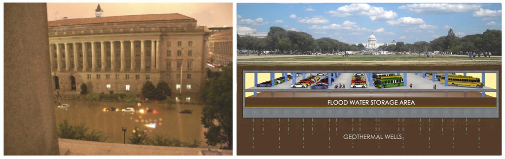
The parking garage and geothermal components of the Underground provide solutions to other urgent needs, including clean energy for nearby public buildings and parking for tour buses that are now major sources of traffic congestion and air pollution.

During the webinar, exhibits presented will include photographs of historic Mall floods, maps illustrating the geography of flooding on the Mall, and recent reports raising new alarms about the scale of the flood threat to the public buildings and open spaces of the Mall. Speakers will include Arthur Cotton Moore, architect of the Underground, and Judy Scott Feldman, chair of the Coalition. 

The Architecture Month theme “Civic Spirit” is perfectly apt for the Underground, since any solution to the stormwater flooding threat requires collaboration among a number of entities. The list responsible for Mall oversight includes congressional committees, federal agencies, DC government, plan review bodies, and others. 
 
Architecture Month 2020 is co-produced by the Washington Architectural Foundation and the Washington Chapter of the American Institute of Architects. Learn more at aiadc.com/ArchitectureMonth2020
 
Date: June 3, 2020
Time: 5:00 to 6:00 pm
Place: Online only
Price: Free
Register: AIA registration form (general public as well as students and AIA members invited)
or register directly at this link.
Architecture Month 2020: Civic Spirit: View the complete calendar of events

Devastating Floods are a Historic and Ongoing Problem for the National Mall (slideshow)

  • Devastating Floods are a Historic and Ongoing Problem for the National Mall (1889 Photo courtesy Library of Congress)
  • Devastating Floods for the National Mall (1930 Photo courtesy Library of Congress)
  • 1942 East Potomac Park and the Jefferson Memorial (Photo courtesy Library of Congress)
  • 1985 East Potomac Park with the Washington Monument in the distance (Photo courtesy Library of Congress)
  • In fact, Washington has two separate flood threats: river flooding and stormwater flooding
  • Potomac River flooding has inundated, clockwise from upper left, Pennsylvania Avenue at 6th Street NW in 1889, the Navy Yard in 1936, East Potomac Park (before the Jefferson Memorial) in 1936, and Washington Harbour in Georgetown in 2010
  • The stormwater flood of 2006, by contrast, was caused by runoff from heavy rains on higher ground into this lowest lying part of the city along Constitution Avenue. (Image courtesy Arthur Cotton Moore)
  • This “interior” flooding caused millions of dollars in damage to, clockwise from upper left, federal office buildings, the Department of Justice, the basement theater in the National Archives, and the 12th Street tunnel under the Mall
  • These flooding problems are the result of Washington’s topography and changes made to rivers and streams over the years
  • This 1793 topographic map by Andrew Ellicott shows the site chosen for the nation’s capital at the confluence of the Potomac and Anacostia (Eastern Branch) Rivers with a broad creek – Tiber Creek – wending its way along the Mall area from the Capitol to the Potomac
  • A satellite view of modern Washington superimposed on Ellicott’s 1793 topographic map shows Tiber Creek (now covered by Constitution Avenue) and the original shorelines of the Potomac and Anacostia (outlined in black).
  • This diagram illustrates that while the levee may prevent Potomac River flooding (the area outlined in red), it will not address the separate interior stormwater flooding problem.
  • No government action has been taken to address the ongoing stormwater flooding threat by implementing the recommendations of the 2011 Federal Triangle Stormwater Drainage Study sponsored by DC Water and the National Capital Planning Commission. Lacking a plan, Metro officials use sandbags to protect the Metro system from stormwater flooding.
  • Washington’s flood threats continue to be well documented in recent government and private studies but no comprehensive plan has been developed
 

Tags: , ,


More Posts in National Mall Coalition Blog